Geology
at Tajo Internacional and the Armorican Quartzite route
The Biosphere reserve and the Tajo Internacional Nature Reserve are located in the western part of the Iberian Peninsula right on the border which joins Extremadura and Portugal. Here the River Tajo (“cut”) lives up to its name and splits its banks into two hills, valleys, and numerous rocky formations to give them a unique ecosystem, numerous prehistoric relics, and a great variety of minerals.
Geology is the natural science of the study of the earth and its relationship with the environment and is another attraction of this territory, which has had a turbulent history from a geological point of view and has left very interesting remains.
Tajo Internacional is an area of low altitude with steep relief and with the River Tajo as the backbone of the territory. Its tributaries, the Sever, Pónsul, Aravir, and Erjas, border the peneplain and have shaped a unique geological space.

Its geology
A trip through Tajo Internacional reveals a surface full of slates and granite rocks. The origin of a large number of these granite rocks lies in Hercynian orogeny, the movement of tectonic plates which created mountains in particular in the vicinity of the Erjas and Sever Rivers. The pebbles which make up the ‘raña’ (reddish clays and sands) in the vicinity of the River Erjas, in addition to more recent sediment, come from the river terraces and minor sandy deposits related to these courses.
The small diabase dykes, the famous ‘lode stones’, as they are called by the inhabitants of Tajo Internacional, are striking. These slates were formed on the seabed and occupy the territory by sedimentation. Indeed many marks of the swell, which are known as ripples, can be observed in the relief of these rocks and throughout the territory.

Land under the sea
The geological origin of Tajo Internacional is Precambrian, the original and longest stage of the history of the planet Earth over 600 million years ago. A marine hillside of a depth of between 200 and 1000 metres deposited sediments of sands, mud, and clays which led to the birth of other materials which make up the so-called ‘Schist-Greywacke Complex’.
Subsequently sediments continued to accumulate. The movements which would give rise to irregularities such as uplifting and folds took place during the period of Hercynian orogeny (some 300 million years ago). The famous Tajo Peneplain is of later origin; it was caused by the strong erosion of the rivers which flowed into the Mediterranean and levelled the base present at that time.
For its part, Alpine orogeny contributed to the fact that the current slope is towards the west. It was at that time that the large blocks which caused furrows in the ground made their appearance; these furrows would later be filled by the courses of the rivers.
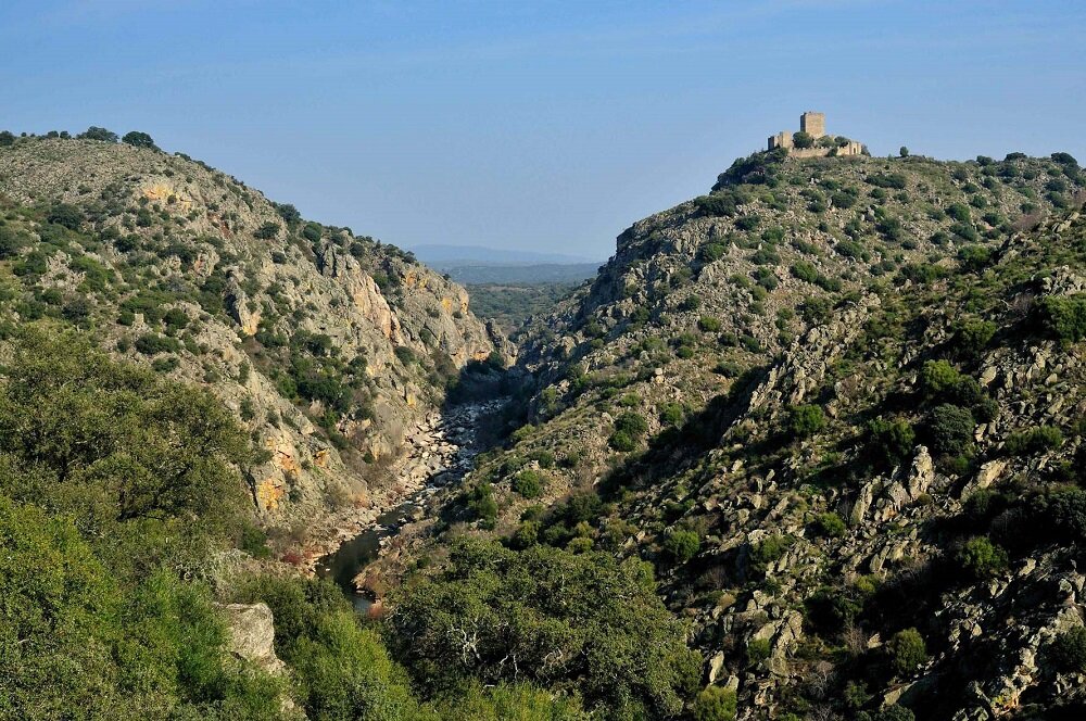
Canyons in Tajo Internacional
A “tajo” is a cut, and here the River Tajo divides these lands as its name suggests. The river plunges sharply into a peneplain but does not create a real valley. The green of the landscape is interrupted by this immense river which gives rise to banks and hillsides with steep slopes near it and its tributaries. It is for this reason that locals always say that “here to go to the sierra you have to descend” as over a small area there are differences in height of up to 200 metres. You will discover that there is no need to go to Colorado to see canyons because those of the Tajo Internacional Biosphere Reserve are truly impressive.
In the north-eastern part of this territory we can enjoy the imposing river canyons of Peñafiel and Segura, a terrain in which the River Erjas cut into the granite surface to cause a great fracture which took the form of a deep narrow canyon of vertical walls.
Moreover, on the fastest sections of the courses of the Sever, Erjas, and Salor Rivers potholes appeared; these formations originate from the time of the glaciations. Here with the help of the sands and gravels the water has penetrated the rocks to produce an unusual aquatic landscape.


An Armorican Quartzite route
With this excursion you will discover the geological wonders of the Tajo Internacional Bisophere Reserve. You will learn to distinguish the different types of rocks (sedimentary, igneous, or metamorphic) and the tectonic structures (faults, synclines, anticlines…) or the types of modelling the land such as the peneplain, clefts, or “dog’s teeth” formations. You can begin this route in Zarza la Mayor and make geostrategic stops to interpret the landscape: the peneplain, the Armorican Quartzite, the various strata, Palaeozoic tectonics, the sediments of the Cenozoic, the cleft of the River Tajo, and the canyons of the River Erjas.
This route is a conglomerate of the various geological processes through which the Internacional Biosphere Reserve has passed over time, the result of which is the current landscape.
The Berrocal
de la Data
A geological treasure
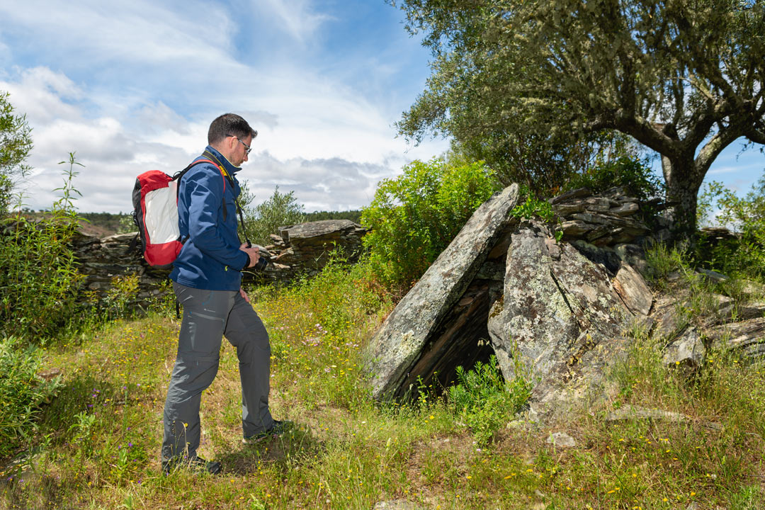
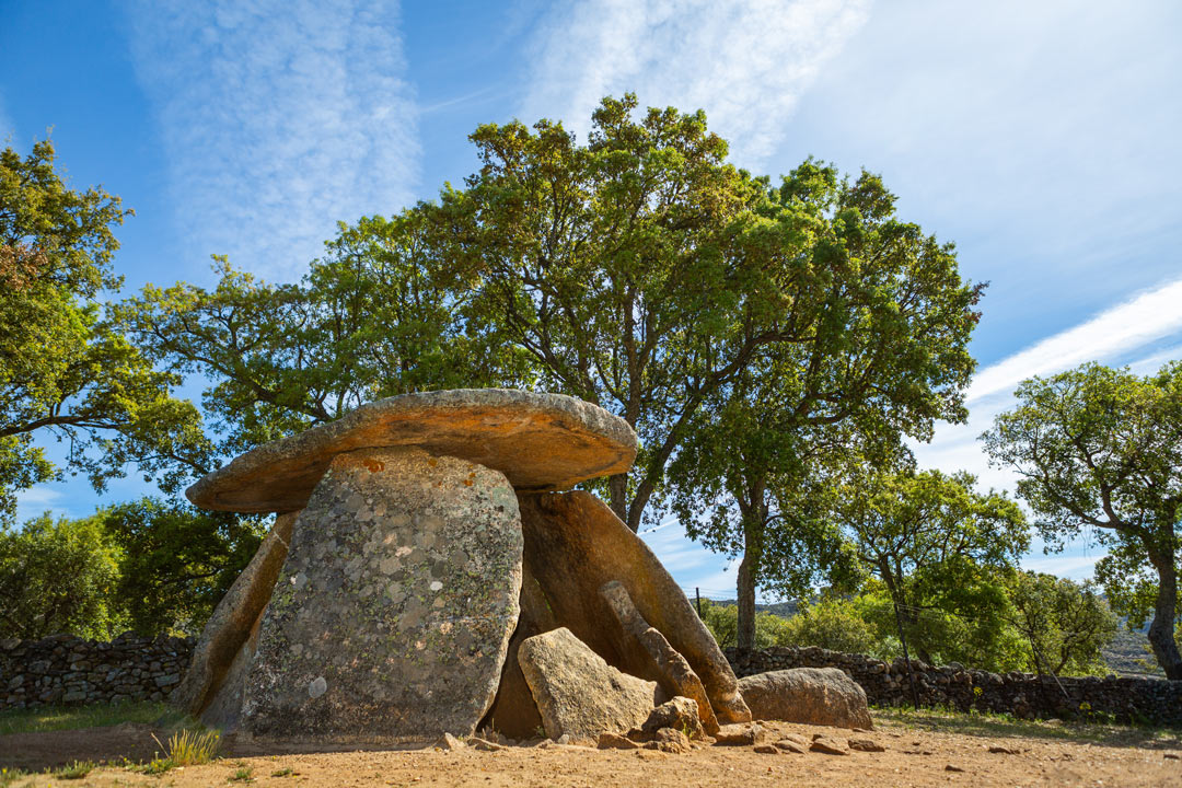
The capricious forms of the granite rocks of the Berrocal de la Data make up a dream-like landscape which is almost from another world. On overcast days this geological formation takes on a most mysterious air in harmony with the megalithic monuments which surround it. The griffon vultures nesting in the vicinity give added value to the space.
La Data is in a ZEPA and belongs to the municipal district of Valencia de Alcántara. Here human beings have left their mark in the form of 5 dolmens and various cave paintings. Its dark skies and negligible light pollution make this place not only a geological treasure but also an impressive landscape for enjoying astrophotography.
La Data se encuentra en zona ZEPA y pertenece al término municipal de Valencia de Alcántara; it belongs to the select club of the Natural Monuments of Extremadura together with Los Barruecos, the Castañar Cave, the La Jayona Mine, and the Fuentes de León Caves.
It has been a Natural Monument since December 2020.